The Great Mississippi Flood of 1927 was by all accounts a biblical event. It started raining in August of 1926 and didn’t stop for 8 months. When all was said and done, 630,000 people were affected by the flood event. It was then realized that something more needed to be done. The Flood Control Act of 1917 wasn’t enough. Under the direction of the Secretary of Commerce, Herbert Hoover, the United States Army Corp of Engineers was tasked with taming the Mississippi River with The Flood Control Act of 1928. This act started the project which is known as The Mississippi Rivers & Tributaries Project (MR&T). The USACE Mississippi Valley Division was responsible for planning and constructing the world’s longest system of levees and flood control works. Within that project is the Atchafalaya River. The Atchafalaya River currently carries all of the water from the Red River and 30 percent of the water of the Mississippi River right through St. Mary Parish discharging to the Gulf of Mexico through the Atchafalaya River and Wax Lake outlet. The 30 percent coming from the Mississippi River is controlled near Simmesport, Louisiana by what is called the Old River Control Structure. Completed in 1963, it consists of a low-sill and overbank structures, an auxiliary structure, a hydroelectric station and a navigation lock.
Further control of the Mississippi River can be done by utilizing the Morganza Spillway. This spillway can divert additional waters from the Mississippi River down the Atchafalaya River when the major ports of Baton Rouge and New Orleans are threatened by high river levels. The Morganza Spillway has only been operated twice since its construction in 1954. The floods of 1973 and 2011 were historic enough for the need to utilize the Morganza Spillway. During both of these openings as well as an additional time in 2016 it was realized that these river levels would cause backwater flooding through the Bayou Chene.
Another major component of the MR&T system in our district is the Wax Lake Outlet. This outlet was created in 1942 to divert 30 percent of the flow of the Atchafalaya River out to the Gulf of Mexico in order to reduce the river stages in Morgan City.
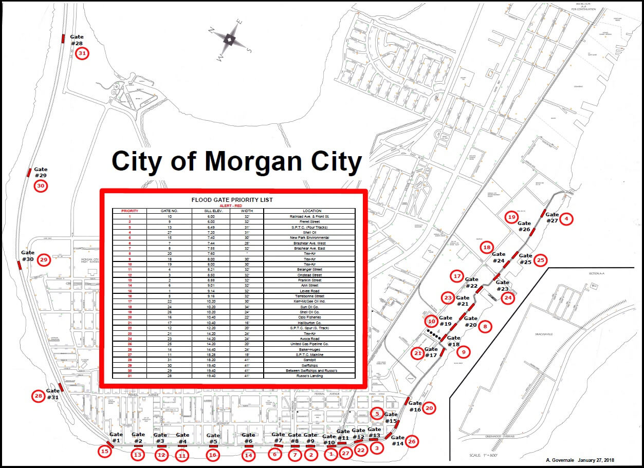
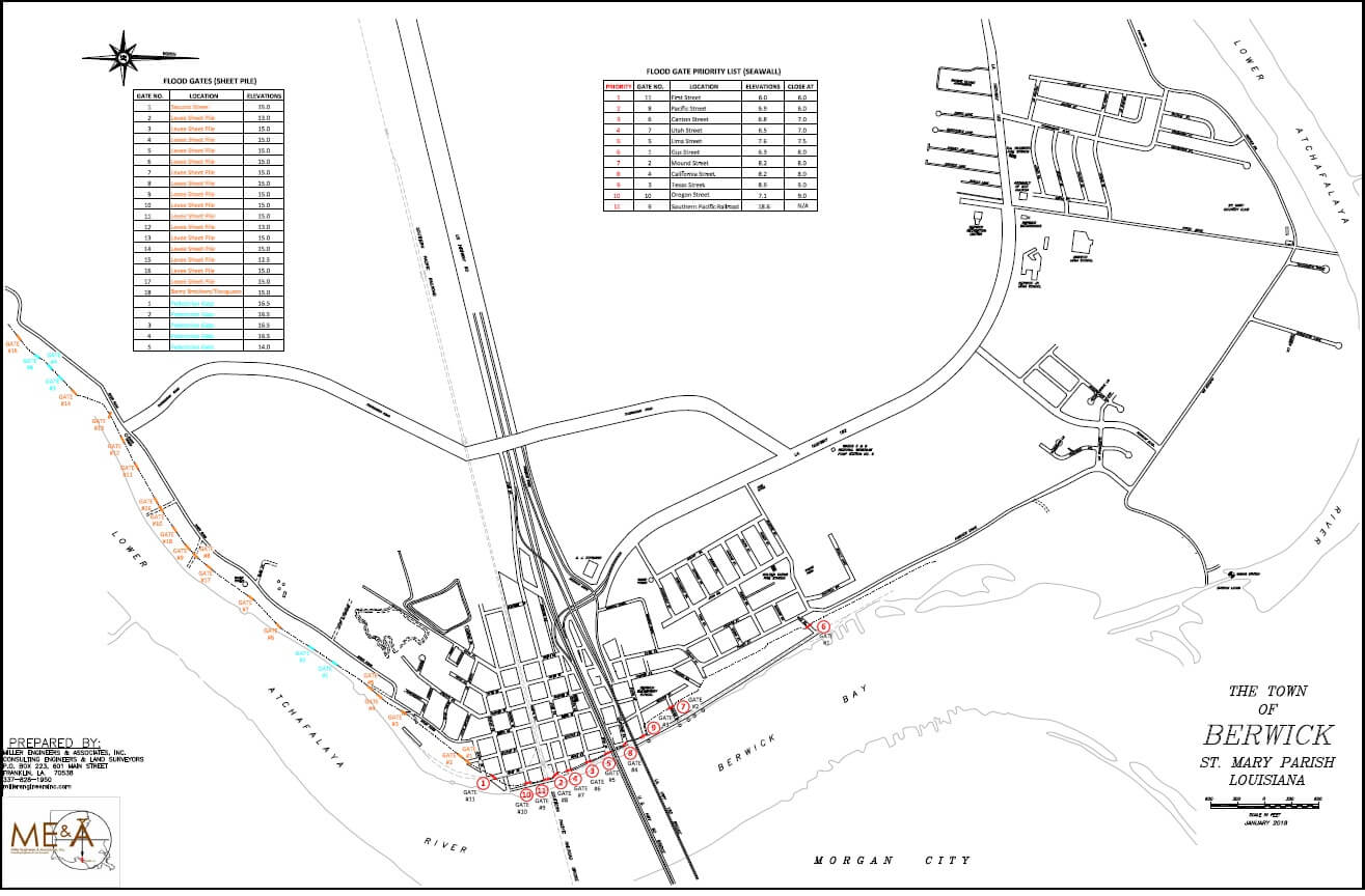
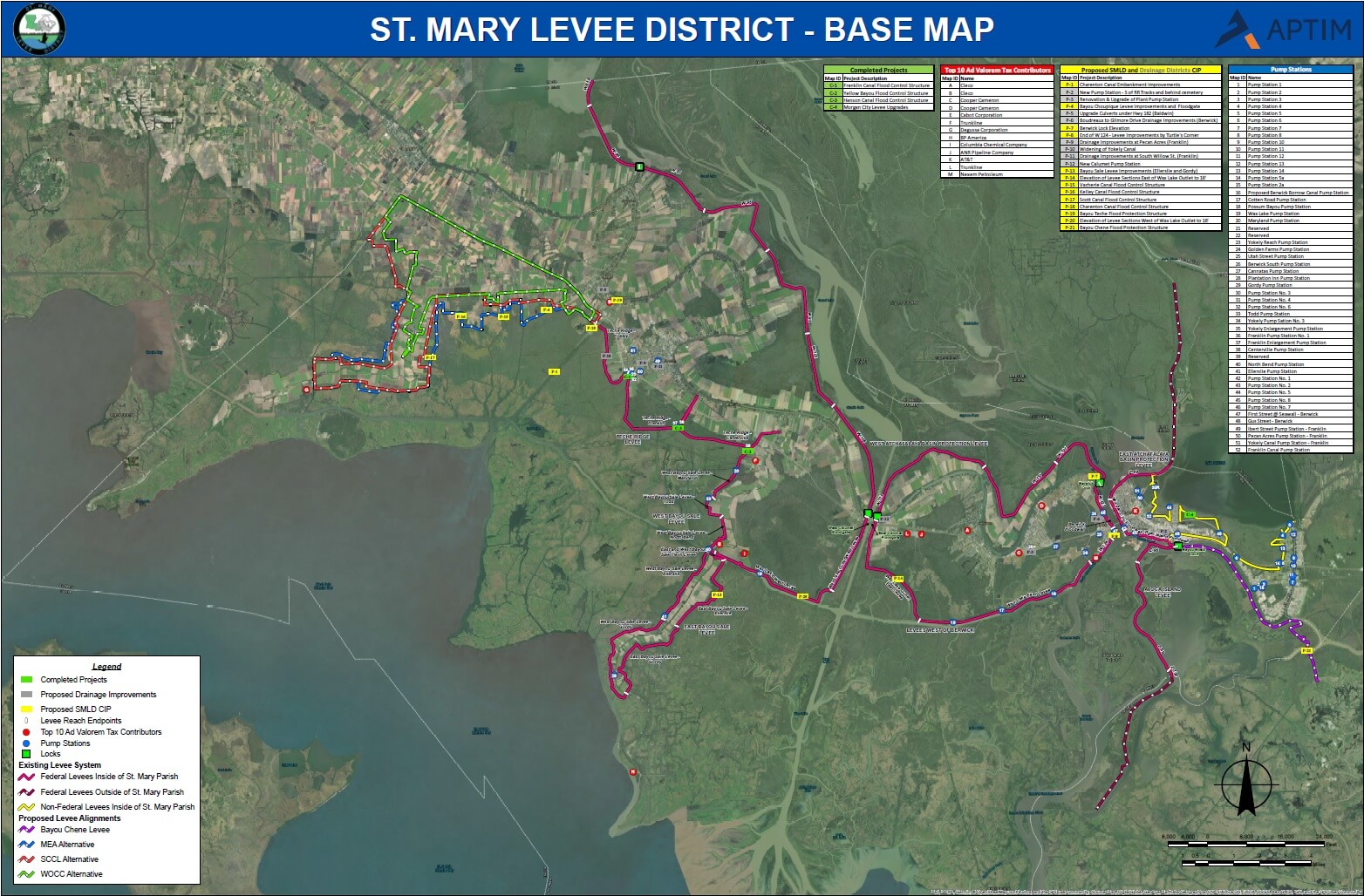
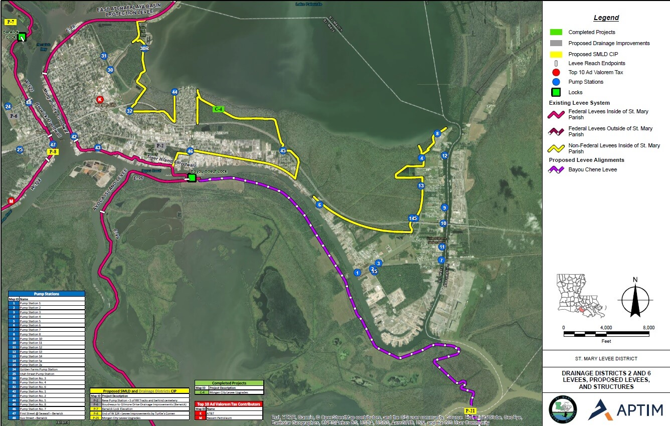
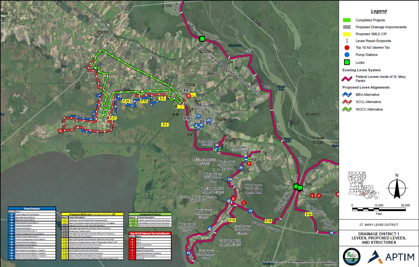
So what protects St. Mary Parish from the threats of these upstream floods that have to pass through our parish? The federally mandated MR&T system. It is a system of levees, flood walls, flood gates, pump stations, and locks that protect the people and property inside the system. There are approximately 120 miles of federal MR&T levees in St. Mary Parish as well as an additional 10 miles of backwater protection. The St. Mary Levee District is the local sponsor for all of these levees. We are responsible for maintaining and operating the levees, floodwalls and some of the flood gates in the parish of St. Mary. In our district currently there are 5 federally operated flood gates or locks and 3 locally operated. With the future development of at least 2 more flood gates (Bayou Teche and Bayou Chene).
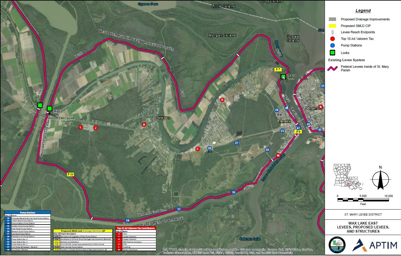
Bayou Boeuf Locks (USACE)
Berwick Locks (USACE)
East Calumet Flood Gate (USACE)
West Calumet Flood Gate (USACE)
Charenton Canal Flood Gate (USACE)
Franklin Canal Flood Protection Structure (SMLD)
Hanson Canal Flood Gate (SMPG)
Yellow Bayou Flood Protection Structure (SMPG)
While it is the task of the levees to keep the river and surge water out of the system, there comes the need to get the rainfall within the system to the outside of it. That falls under the direction of the local drainage districts. There are 5 locally operated drainage districts in the parish with a total of 52 pump stations. Some of these pump stations are a part of the federal MR&T system and are operated on a cost share basis by the locals. A vast majority of the stations in the district are locally owned and operated by the drainage districts and municipalities.
The St. Mary Levee District fights the dual threats of river and hurricane storm surge events. Although the MR&T system was put into place for riverine flood events, they serve a dual purpose. The same levees that protect us from river floods also protect us from hurricane storm surges. Most of our recent work and expansion of the system is the continued effort to better protect the district from storm surge. We have, through time and experience, realized gaps in the system that allow water into places that affect people and property. These gaps and weaknesses are being closed off with flood structures and higher levees. The St. Mary Levee District will continue to strengthen the system to make sure that the district is prepared for whatever may come.